


Keeping drivers on track: how Live Link enabled safer roads for the TT Races
- Zero
- instances of motorists using GPS apps driving the wrong way down the one-way system for the first time since 2005

About the Isle of Man Department of Infrastructure and the TT Races
The Isle of Man Department of Infrastructure (DOI) oversees all transportation matters, including planning, coordinating, and communicating highway maintenance and improvement projects.
Besides their transport responsibilities, the DOI also plays a vital role in supervising significant events, particularly the renowned Tourist Trophy (TT) Races.
The Challenge
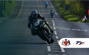
Since its start in 1907, the TT Races have captivated motorsport fans globally. Each year, over 77,000 spectators gather to witness the top road racers in the world tackle the 37.73-mile Mountain Course on the island’s public roads.
However, every year the DOI encountered a recurring communication challenge regarding the event; approximately 10 to 20 motorists each year try to drive down closed roads, following their GPS navigation systems, which unfortunately did not always consider temporary road closures or changes to the network.
This was especially prevalent on the A18 Mountain Road, which turns into a one-way road for the duration of the two-week event.
The races’ long history compounded the problem, as changes to road closure plans each year resulted in increased confusion among drivers.
Driving against one-way systems and on closed roads is dangerous in any situation, but the collision and fatality risks increase significantly without speed limits and with high-performance motorcycles on the roads.
The DOI recognized that ensuring the safety of road users during the races was of utmost importance. They were eager to enhance overall navigation around the island for TT Races attendees and tourists visiting the island.
Therefore, the DOI aimed to take proactive measures to improve communication and road safety on the Isle of Man.
The Solution
For the 2023 TT Races, the IoM Highway Services Regulations Team trialed Causeway one.network and Live Link – our real-time road and lane closure solution.
During the event, the Force Incident Managers collaborated with the IoM Constabulary, utilizing Live Link to block roads throughout the island and disseminate the information to all major GPS apps in almost real-time. This encompassed Google, Apple Maps, Waze, TomTom, and Here Technologies.

To guarantee smooth communication and accessibility for the public, each scheduled closure was also pre-published on the Causeway one.network map and shared via the Isle of Man’s Facebook page, offering clear visibility to the public and supplying local radio stations with an accurate and up-to-date source of information.
The Results
Thanks to Live Link, for the first time since the introduction of the TT Races one-way system on the A18 Mountain Road section in 2005, there were zero instances of drivers using GPS systems that went the wrong way.
The public received closure and disruption info directly to their GPS apps, helping them navigate around the island smoothly and safely.

“Live Link was an absolute must during TT. It was simple to use and added an additional layer of safety for the traveling public.”
– Darren Bradford, IoM Highways Regulations and Events Officer
The DOI also published the road closure plans on both one.network and social media in advance, allowing the public to self-serve and plan their journeys more effectively, thereby decreasing the volume of calls to DOI phone lines.
The overwhelmingly positive feedback from law enforcement further solidified Live Link’s crucial role in ensuring public safety during the event.
“Live Link allowed us to get the right information to the right people at the right time, without relying on confusing language. We could communicate the closures directly to the GPS apps the public were already using.”
– Michael Taylor, Road Policing Sergeant, Isle of Man Constabulary
Moreover, by communicating road closures to GPS systems, ambulance drivers on the island obtained access to real-time closure data, ensuring that, if necessary, they could promptly respond to emergency calls without the risk of delays.
Having felt the transformative impact of Live Link during the races, both the DOI and the police hope to implement the solution in the future for their daily road closure communications.
“I think Causeway one.network and Live Link are crucial for us. If rolled out to police, it will simplify the laborious road closure admin and communication process.”
– Michael Taylor, Road Policing Sergeant, Isle of Man Constabulary
Key Outcomes
- Zero cases of drivers using GPS that went the wrong way since the implementation of the TT Races one-way system on the A18 Mountain Road section in 2005.
- Decreased phone inquiries to DOI phone lines by enabling the public to self-serve and plan their trips via one.network.
- Enhanced emergency services’ capability to react to incidents by communicating closures to GPS apps in nearly real-time.
For more information on how Live Link can help you increase road safety and enhance public communications, get in touch.
